- Length / route type: about 45 miles (72 km) across Delaware, point-to-point thru-route, per discoverytrail.org and Wikipedia
- Surface: a mix of bike trails, sidewalks, and rural roads, beginning on beach and pine forest, per discoverytrail.org
- Parking and fees: the eastern terminus sits inside Cape Henlopen State Park, which charges a seasonal entrance fee; current rates are on the Delaware State Parks site. Most of the rest is public road with roadside parking
- Difficulty: moderate overall; the terrain is flat but the distance is long and much of it is road-walking with vehicle traffic
- Restrooms: at the Monroe Avenue trailhead in Lewes; none confirmed on the rural road segments
- Camping: primitive camping along the route at Redden State Forest, per discoverytrail.org
- Dogs: no single rule covers a 45-mile road-and-trail route; dog rules differ by the park, trail, or town you’re in
- Official source: American Discovery Trail Society
- Last verified: 2026-06
The American Discovery Trail starts in Sussex County and ends 6,800 miles away on a California beach. The first 45 of those miles cross Delaware, from the Atlantic at Cape Henlopen to the Maryland line near Bridgeville. This is the complete walk-through of the Delaware segment, leg by leg, pulled from the official route description.
The American Discovery Trail is the only non-motorized coast-to-coast trail in the United States, and Delaware holds its eastern end. The combined route runs 6,800 miles through 15 states plus the District of Columbia, according to discoverytrail.org.
It splits into a northern and a southern route across the country, then rejoins. That split is why the total mileage far exceeds a single 3,000-mile crossing.
What follows is the Delaware portion in geographic order, west from the ocean.
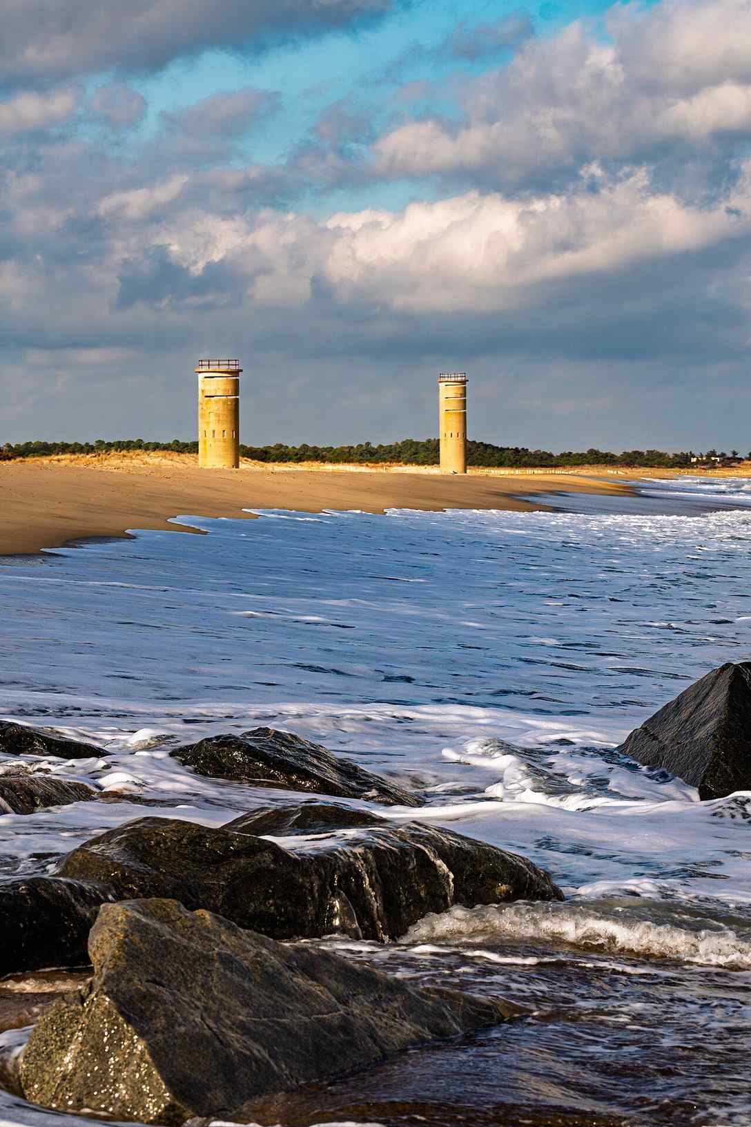
The eastern terminus: a beach bunker at Cape Henlopen
The whole trail begins on the Atlantic Ocean beach inside Cape Henlopen State Park. There’s no trailhead arch or visitor desk marking it. The marker is a sign on a concrete bunker.
That bunker is a leftover of Fort Miles, a World War II-era U.S. Army coastal fort. Several of its fortifications still stand. One of them carries the sign naming it the eastern terminus, per the ADT Society.
The bunker doubles as a viewpoint over the ship traffic entering and leaving Delaware Bay. It’s a working spot, not a monument, which suits a trail that spends most of Delaware on ordinary roads.
Delaware was the first state to ratify the U.S. Constitution. The ADT Society notes that history as the reason the coast-to-coast trail begins here.
For the wider picture of the park’s trails, see the full Sussex County hiking guide. The nearby Gordons Pond Trail covers the park’s boardwalk-and-lagoon side.
Cape Henlopen to Lewes
Leaving the beach, the route heads into the town of Lewes. It passes the Cape May/Lewes Ferry terminal, where boats cross Delaware Bay to Cape May, New Jersey, per discoverytrail.org.
This opening stretch is the beach-and-pine-forest section the ADT describes before the trail turns inland. Wikipedia lists the Cape Henlopen Bike Trail among the trail’s affiliated routes in Delaware.
Lewes calls itself the “first town in the first state,” and the claim has history behind it. In 1631, Dutch settlers founded Zwaanendael here, the “Valley of the Swans,” meaning it to be an agricultural and whaling settlement. That makes it the site of the first permanent European settlement in Delaware, commemorated today by the town’s Zwaanendael Museum.
The ADT Society describes Lewes as a town of about 2,500 people with shops, restaurants, and motels. That figure is the Society’s own characterization rather than a census count, so treat it as rough context.
Through Lewes on the Georgetown-Lewes Trail
Inside Lewes the ADT picks up the Georgetown-Lewes Trail, an asphalt rail-trail on the bed of the former Delaware Coast Line Railroad. This is the longest stretch of dedicated, car-free path on the Delaware segment.
As of 2024, eleven miles were open. The full 17-mile link between Lewes and Georgetown is funded by a federal RAISE grant, with construction targeted for the end of 2026, per Delaware Greenways. A separate tally from TrailLink puts the open trail at 9.6 miles; the gap comes down to which connector sub-segments each source counts.
The Monroe Avenue trailhead in Lewes is the best-equipped stop on this whole segment. It has parking, clean restrooms, a water bottle filling station, a fountain, an information kiosk, and a bike repair station.
At Gills Neck Road, the Georgetown-Lewes Trail meets the Junction & Breakwater Trail heading toward Rehoboth Beach. The ADT doesn’t follow that branch, but it’s a useful junction to know if you’re piecing together a longer car-free outing.
Lewes to Milton: paved country roads
Past the rail-trail, the ADT leaves dedicated path behind. It follows paved country roads into Milton, per discoverytrail.org.
Milton sits on the Broadkill River, which empties into Delaware Bay. The ADT Society notes it was the shipbuilding capital of Delaware in the 1800s. Many fine Victorian mansions from that era still stand in town.
This is where the trail’s character shifts for good. From here to the Maryland line, most of the route is on public roads through small towns and farmland, not separated trail.
Milton to Redden State Forest: farm roads and a watershed line
Out of Milton, the route runs on rural roads through farmland. Soon after it crosses U.S. 113, it enters Redden State Forest, per discoverytrail.org.
Redden is Delaware’s largest state forest at more than 14,000 acres across 18 tracts, sitting in central Sussex County just north of Georgetown. The Delaware Forest Service lists over 44 miles of trails here for hiking, horseback riding, bicycling, and bird watching, per agriculture.delaware.gov. The tree cover is loblolly pine mixed with oak, maple, and gum.
Passing through Redden, the ADT crosses the divide between the Atlantic Ocean watershed and the Chesapeake Bay watershed. Rain falling on one side of that line drains to the ocean; rain on the other drains toward the bay. It’s the kind of quiet geographic fact a road-walk can hide if you don’t know to look for it.
The forest is also the segment’s camping option. Its Headquarters Tract, on East Redden Road, has eighteen primitive camping sites and a small catch-and-release fishing pond.
The same 1,836-acre tract holds the 4.0-mile Headquarters Loop Trail on packed earth, rated easy by Delaware Greenways. A natural resource education facility in a former carriage house, opened in 2000, sits on the same grounds.
For a closer look at walking Redden on its own, see the Redden State Forest trails guide.
Redden to Bridgeville and the Maryland line
West of Redden, the ADT continues to Bridgeville. The ADT Society describes it as a town of 1,500 people and the agricultural and former railroad center of the region.
That population figure is worth a flag. The 2020 U.S. Census puts Bridgeville closer to 2,568, so the ADT page is likely using an older or estimated number. The “agricultural and former railroad center” description still fits the town’s role on the route.
After Bridgeville the trail threads country roads through several unincorporated communities. It leaves Delaware on Rural Road 113, which becomes Hobbs Road across the state line in Maryland. The boundary it crosses here was part of the original Mason-Dixon Line, per discoverytrail.org.
Completing 45 miles in Delaware equals nearly 1% of the coast-to-coast trail.
Planning the route
The ADT in Delaware is not a single marked footpath you can follow on instinct. It’s a stitched-together corridor of bike trail, sidewalk, and rural road. The official route data matters more here than it would on a self-contained loop.
The turn-by-turn route is available only from the ADT Society itself. Effective January 1, 2026, route data became a free download by state, region, or nationwide from discoverytrail.org, made possible by a gift from Indiana Trails. You can pull just the Delaware data or the full nationwide file, and separate official routes exist for walkers and for cyclists.
A few planning notes specific to this segment:
- The road-walking is real. Outside the Georgetown-Lewes rail-trail and the Redden forest roads, much of the 45 miles shares pavement with cars. Plan for shoulders, traffic, and few sidewalks between towns.
- Camping is limited to Redden. The eighteen primitive sites in the Headquarters Tract are the only on-route camping the ADT Society names in Delaware. Lewes offers motels at the eastern end.
- Towns are your resupply. Lewes, Milton, and Bridgeville are spaced along the route with services; the stretches between them are rural.
- Fees apply only at the start. The Cape Henlopen terminus sits inside a fee-charging state park; the road miles that follow don’t carry an entrance fee.
The Society also sells memberships that help maintain the route.
One honest gap: there’s no published mileage for the individual legs. The only official distance is the “about 45 miles” total. Segment-level mileages presumably live inside the downloadable route file, so pull it first if you’re planning daily distances.
Frequently asked questions
Where does the American Discovery Trail start?
Its eastern terminus is on the Atlantic Ocean beach inside Cape Henlopen State Park in Lewes, Delaware. The marker is a sign on a surviving World War II bunker from the old Fort Miles. It’s also a good spot to watch ships entering Delaware Bay.
How long is the American Discovery Trail in Delaware?
About 45 miles, or 72 kilometers, per the ADT Society and Wikipedia. That’s the only official distance published; the route is not broken into per-leg mileages on the public state page.
Is the Delaware segment all hiking trail?
No. It’s a mix of bike trails, sidewalks, and rural roads. The dedicated car-free portions are the Georgetown-Lewes rail-trail and the forest roads through Redden; much of the rest is public road through towns and farmland.
Can you camp along the route in Delaware?
Yes, at Redden State Forest. Its Headquarters Tract on East Redden Road has eighteen primitive campsites and a small catch-and-release fishing pond. It’s the only on-route camping the ADT Society names in the Delaware segment.
How do I get the official map or GPX?
From the ADT Society at discoverytrail.org. As of January 1, 2026, the route data is a free download by state, region, or nationwide, with separate files for walkers and cyclists. The official route is available only from the Society.
Photo: Andrew Parlette (CC BY 4.0), via Wikimedia Commons.
.jpg)
Last verified: 2026-06.